Kriging is a more complex form of interpolation than inverse-distance. It generally produces superior results to the inverse-distance algorithm but requires more computer memory and time.
To perform kriging in Tecplot 360 EX, perform the following steps:
1.Read the dataset to be interpolated into Tecplot 360 EX (the source data).
2.Read in or create the zone onto which the data is to be interpolated (the destination zone).
3.From the Data menu, choose Interpolate>Kriging
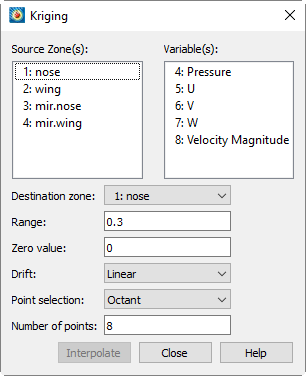
4.From the Kriging dialog, select the zones to be interpolated from those listed in the Source Zone(s) scrolled list.
|
|

5.Select which variables are to be interpolated from those listed in the Variable(s) scrolled list.
6.Select the destination zone into which to interpolate. Existing values in the destination zone will be overwritten.
7.In the Range text field, optionally enter the distance beyond which source points become insignificant for the kriging. The value is stated as the fraction of the length of the diagonal of the box which contains the data points. A range of zero means that any point not coincident with the destination point is statistically insignificant; a range of one means that every point in the dataset is statistically significant for each point. In general, values between 0.2 and 0.5 should be used.
8.In the Zero Value text field, optionally enter the semi-variance at each source data point on a normalized scale from zero to one. Semi-variance is the certainty of the value at a data point. A value of zero means that the values at the source points are exact. Greater values mean the values at the source points have some uncertainty or noise. Zero is usually a good number for the zero value, and it causes the interpolated data to fit closely to all the source data points. Increasing the zero value results in smoother interpolated values that fit increasingly more to the average of the source data.
9.Select the overall trend for the data in the Drift drop-down. This can be Linear (default), None, or Quadratic.
|
|
 If the
 10.Select the method used for determining which source points to consider for each destination point from the Point Selection drop-down. There are three available methods, as follows:
• Nearest N - For each point in the destination zone, consider only the closest n points to the destination point. These n points can come from any of the source zones.
• Octant (default) - Like Nearest N above, except the n points are selected by coordinate-system octants. The n points are selected so they are distributed as evenly as possible throughout the eight octants. This reduces the chances of using source points which are all on one side of the destination point.
• All - Consider all points in the source zone(s) for each point in the destination zone. In general, you should not use the All option unless you have very few source points
|
|
 The
The .
11.Click Interpolate to begin kriging. While kriging is proceeding, a progress bar appears in the status bar, along with a Stop button that can be clicked to interrupt the operation.
|
|
 If you interrupt the kriging process, the destination zone is left in an indeterminate state, and you should redo the kriging or delete the destination zone.
The Kriging Algorithm
For a detailed discussion of the kriging algorithm refer to: Davis, J. C., Statistics and Data Analysis in Geology, Second Edition, John Wiley & Sons, New York, 1973, 1986.
|
|
